


(C) 2012 Nefta-Eleftheria Votsi. This is an open access article distributed under the terms of the Creative Commons Attribution License 3.0 (CC-BY), which permits unrestricted use, distribution, and reproduction in any medium, provided the original author and source are credited.
For reference, use of the paginated PDF or printed version of this article is recommended.
The road network has both positive and negative ecological effects, and understanding these helps identify environmentally preferable solutions for transportation policy and planning. We investigated the relationship between road density and habitat type richness of Greek protected areas. We used digital vector maps of 214 sites included in the Greek Natura 2000 network. We calculated road density for the terrestrial part of each site and correlated it with habitat type richness. Average road density of protected areas (0.377 km/km2) was significantly lower than the national road density of Greece (0.446 km/km2). We identified 32 sites that were not intersected by roads. These roadless sites were located at mountain tops, at islets, or in remote coastal zones. Overall we found no significant correlation between road density and habitat type richness. We suggest that the effect of road networks on habitat type richness is less apparent at landscapes with long history of human presence, because the landscape (and its habitat diversity) has coevolved with human activities over the past millennia. Our analysis provides a step towards quantifying the effect of road density on the diversity of habitats and consequently on species of conservation interest in international networks of protected areas such as the European Natura 2000 network.
Habitat diversity, Natura 2000 network, Protected areas, Road ecology, Road network, Roadless areas, Greece
Biodiversity loss has settled to one of the major environmental problems of the twenty first century, consequently countries worldwide have proceeded to establish protected areas in order to halt the loss and preserve species and habitats of high conservation value. In the European Union, the Natura 2000 network is the largest network for nature conservation extending to all member states. However despite the effort so far, the biodiversity crisis in Europe continues to deepen (
Roads have been reported to have both positive and negative effects on society, whilst reports on the negative impacts on ecological impacts have been widespread. Roads function as ecological corridors for dispersal for many species, but this implies the inclusion of alien and invasive species (
Among the negative road impacts are situations of altered animal behaviour due to roads (reviewed in
The majority of studies on biodiversity loss due to road networks emphasize the effects on species movement (e.g.
Compared to other land use alterations, roads may be the leading mechanism of fragmentation and habitat reduction in protected areas (
Over the past two decades an increased interest in the importance of roadless areas in biological conservation has been observed (
There is pressing need for protected areas’ management to take into account road networks, since the ecological influences of roads may extend hundreds—or thousands—of meters from the roadside, suggesting a direct ecological road effect on most protected areas (
Our goal was the interpretation of road effects on the ecology of protected areas in Greece, thus we focused on the effects of road density on habitat richness in Natura 2000 network. Since the study covers the entire country we considered a landscape level approach (
Greece occupies an area of 131, 990 km2 and has a population of approximately 11 million. Nearly one third of the land comprises lowland plains, valleys and foothill country that is generally fertile and productive. The remaining two-thirds are mostly mountainous terrain. Variation of climatic conditions and geomorphologic characteristics as well as its geographic position create an impressive variety of vegetation types and habitats. In these habitats breed a diversity of terrestrial species (60% of which nest in Greece), reptiles, amphibians and freshwater fish (
Greece, as a member state of the European Union, designated a national network of protected areas to be included in the European Natura 2000 network and by 2011 a total of 419 sites was included in the Greek Natura 2000 database. The study area includes the entire Natura 2000 network in Greece, after taking into account the overlaps of sites designated under the Birds (SPAs) and those under the Habitats (SCIs) Directives, which includes 371 sites and covers more than 22% (29, 249 km2) of the national terrestrial area. These sites cover most geological formations present in Greece (
We studied 214 terrestrial sites included in the Greek Natura 2000 network, for which digital habitat maps were available (60.45% of Natura 2000 terrestrial sites). For these sites the total terrestrial area was calculated after omitting any aquatic (marine or freshwater) areas. A map of the road system (1:500, 000 scale) was overlaid on the Natura 2000 network and GIS analyses were performed using ArcGIS software (
The 214 sites of the Natura 2000 network were characterised as either coastal, forest or freshwater based on the dominant land use and habitat types according to the EU Habitats Directive (92/43/EEC). This information was derived from the Natura 2000 and CORINE Land Cover databases.
We also employed Vector-based Landscape Analysis Tools (version 1.1,
To investigate for any potential relationship between road density across Natura 2000 sites and fragmentation metrics we used non parametric Spearman correlation coefficient; the analysis was repeated by grouping sites within each ecosystem type (i.e. coastal, forest, freshwater). We further used Kruskal-Wallis test to investigate the potential differences between the fragmentation metrics in the three ecosystem types. The relationship between road density and the surface of the sites was assessed by means of linear regression.
Mixed-model regression was applied to analyse the relationship between the road density (dependent variable), habitat richness and altitude (covariates) and their interactions. Ecosystem category was entered as a random factor.
Variables were transformed (log or square root) as necessary to meet assumptions of normality and homoscedasticity of residuals.
A linear regression was applied to provide a more thorough investigation of the relationship between road density and habitat richness.
All statistical analyses were performed with SPSS 18.0 (
The total length of roads in the Natura 2000 network is 8, 625 km while the total surface of Natura 2000 sites intersected by roads is 23, 199 km2. Average road density for the whole 214 sites was 0.37 km/km2 (Fig. 1). 32 sites were found to be roadless, 17 of which are coastal, 9 are forest and 6 are freshwater ecosystems. The total area of roadless sites ranged from 1.29 to 109.33 km2 (mean: 26.87 ± 29.01 km2), which was significantly smaller compared to the remaining 182 roaded sites of the network (mean: 127.46 ± 151.87 km2) (P<0.01). The mean altitude of roadless areas was 257.51 m (± 464.67 m) while the mean altitude of roaded sites was 566.26 m (± 522.90).
Road density in these sites ranged from 0.0004 km/km2 to 2.46 km/km2. The mean road density of the protected areas was significantly lower than the national road density (0.44 km/km2) (all sites: P<0.01; roaded sites: P<0.01). The distribution of road density values in studied sites (n=214) was right skewed; half the areas had low road densities (less than 0.3 km/km2) and only three had road densities greater than 1.50 km/km2 (Fig. 2). Most roaded sites (97%) were intersected by regional roads and/or local roads (76%) and less than half of the protected areas (46%) were crossed by dual carriageways. Roaded sites within the Natura 2000 network demonstrated a significant lower mean density of local (mean= 0.23±0.32 km/km2) and regional (mean= 0.09±0.14 km/km2) roads compared to the country as a whole (in both cases P<0.01). Road density of forested and coastal sites was significantly lower than the national average road density (P<0.01). In contrast, we found no significant difference between road density in freshwater aquatic sites and national road density (P=0.46).
We found no significant correlation between a site’s surface area and road density (P = 0.09).
Our analysis revealed positive and significant correlations between road density and landscape division (rs= 0.59, P<0.01), splitting index (rs= 0.58, P<0.01) and number of patches (rs= 0.46, P<0.01). Similar results were obtained when repeating the analysis by grouping protected sites as coastal, forest and freshwater ecosystems. In contrast, road density was negatively correlated with effective mesh size (rs= -0.17, P<0.05); which however, was not significantly associated with road density when grouping our data into the three ecosystem types.
Effective mesh size was significantly different among the three ecosystem types (Kruskal-Wallis test H=11.29, P<0.01) with higher values supported at the forested sites. No other significant difference was indicated for the fragmentation metrics among the studied ecosystems types (in all cases P>0.05) (Table 1).
When the mixed-model regression was implemented road density was not related to either habitat richness (P=0.29), mean site altitude (P=0.32) or their interaction (P=0.73). Road density was found to be related to ecosystem type (P<0.05) with a higher value observed at freshwater ecosystems (mean=0.49 km/km2) than in coastal (mean=0.36 km/km2) and forests (mean=0.29 km/km2).
In Figure 3 the relationship between habitat richness and road density is illustrated. Sites with low road density values could support either low or high habitat diversity. But as road density increases the variance in habitat richness values among sites decreases. At high road density values, medium habitat richness was observed. Finally, we did not identify any significant correlation between road density and habitat diversity within any of the three ecosystem types.
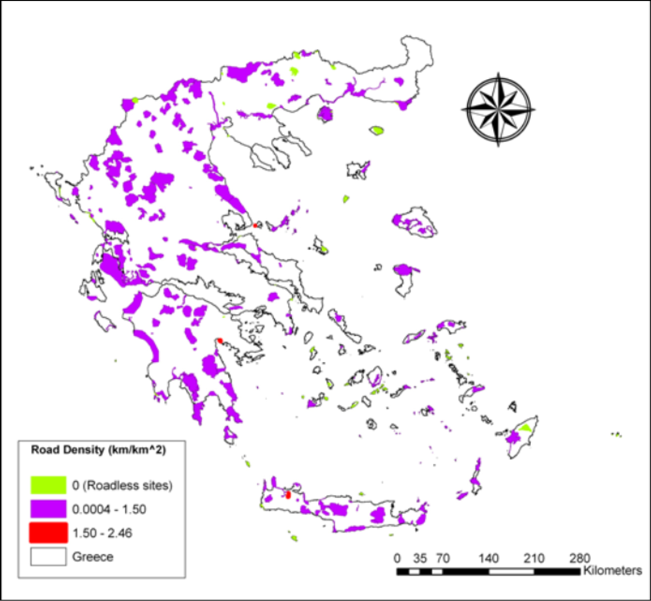
Road density at the Greek Natura 2000 network. Road density values (km/km2) for each one of the 214 studied sites of the Natura 2000 network in Greece. Values ranging from 0 to 2.46 km/km2.
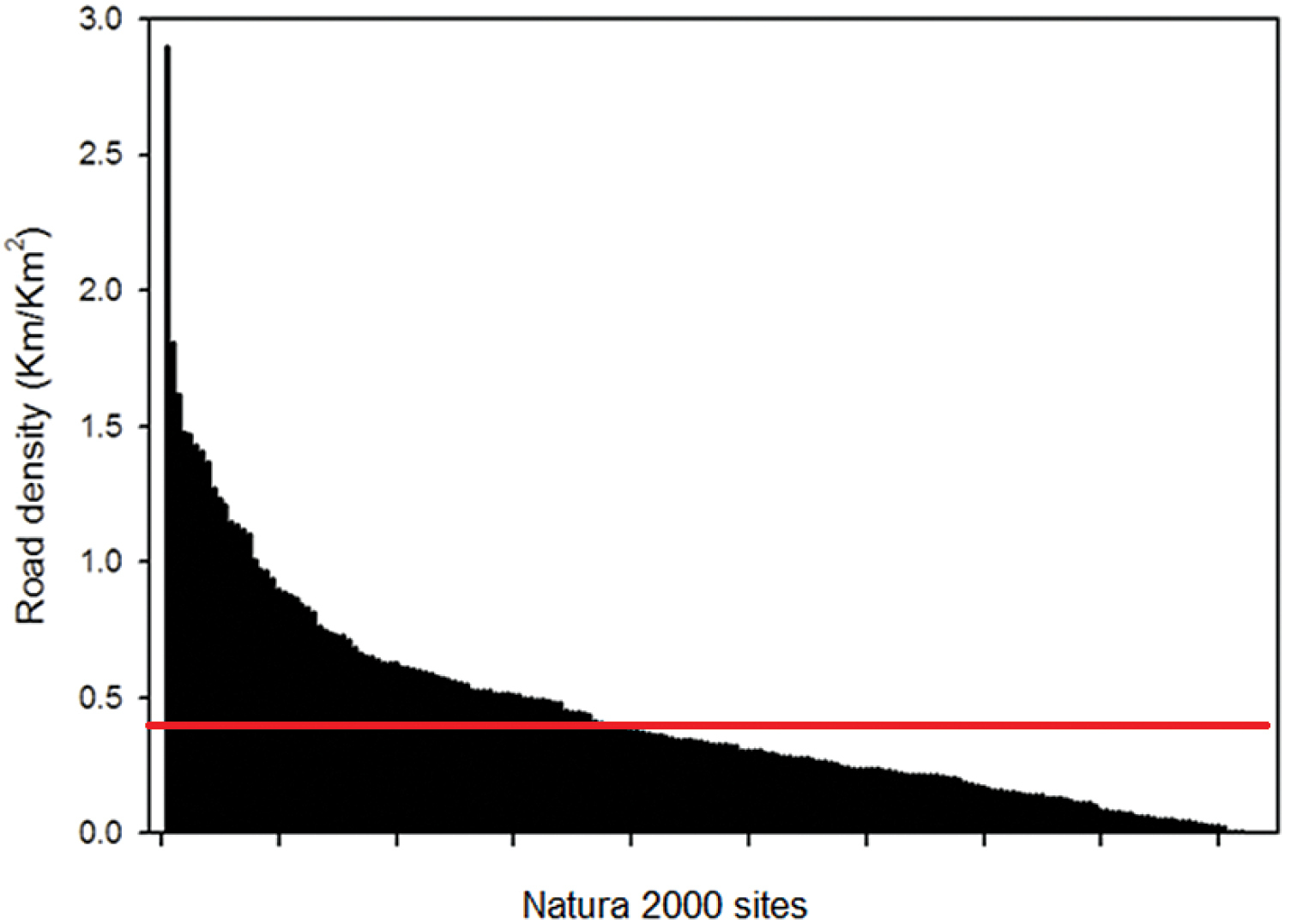
Distribution of road density at Greek Natura 2000 sites. The distribution of road density values (km/km2) in descending order at the 214 studied sites of the Greek Natura 2000 network. The red line depicts the overall national road density, including Natura 2000 sites.
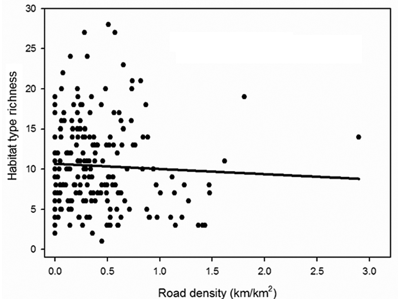
Road density in relation to habitat richness. The relationship of road density (untransformed values) with habitat type richness for the 214 studied sites of the Greek Natura 2000 network.
Descriptive landscape characteristics of road fragmentation in Natura 2000 network based on the three ecosystem types.
| Ecosystem Type | mean Landscape division | mean Splitting index | mean Effective mesh size (km2) | mean Number of pathes | mean Surface area (km2) | mean Habitat types/site | mean Road density (km/km2) | mean Altitude (m) |
|---|---|---|---|---|---|---|---|---|
| coastal | 34.32 (± 29.18) | 2.09 (± 1.51) | 45.29 (± 105.23) | 12.25 (± 13.08) | 84.33 (± 148.29) | 11.6 | 0.36 (± 0.42) | 131.67 (± 156.66) |
| forest | 28.15 (± 25.83) | 1.65 (± 0.78) | 102.77 (± 94.02) | 13.90 (± 14.47) | 154.88 (± 137.42) | 8.47 | 0.29 (± 0.29) | 971.50 (± 468.42) |
| freshwater | 34.86 (± 27.06) | 1.94 (± 1.14) | 44.4 (± 61.65) | 15.27 (± 21.56) | 84.55 (± 139.78) | 9.8 | 0.49 (± 0.30) | 309.8 (± 378.58) |
Although Europe is considered to be the most highly fragmented continent (
Considering the conservation value of roadless areas and the sparse road network in Greece, one might intuitively expect that the majority or at least a high proportion of Greek protected areas would be roadless. Surprisingly though, protected areas without roads represent 15% of the studied sites, covering less than 3% of the area protected under the Greek Natura 2000 network. Nevertheless, these 32 roadless sites might play a significant role in future conservation efforts (
Our results regarding the representation of roadless areas at different elevation ranges are in agreement with similar work in the US, where in many cases roadless areas occur at lower to mid-elevations (
Several studies on road effects have used road density as an indicator for species presence or persistence and they have reported a significant range of critical values for different species(
A closer analysis for the sites with dense road network (>1.5 km/km2) revealed that their high road density values are mainly attributed to their spatial characteristics (extent, shape) and intense human activity. These three sites are of relatively limited extent (0.4 to 4.96 km2) and have an elongated shape. One of these sites is a canyon, with elongated shape and small area (4.96 km2). The other two sites are located in the coastal zones of two highly populated islands popular with tourists. In these latter cases, the intense and permanent human activity in the area has resulted in a dense road system, without apparently affecting the area’s ability to support a rich biodiversity. Nine out of the thirteen sites with road densities greater than 1km/km2 are areas where no conservation status was assigned prior to their incorporation in the Natura 2000 network. This might imply that natural areas which host important habitat types but are not protected under national or European legislation, have been vulnerable to the expansion of the road network in Greece.
Fragmentation metrics are advocated as a powerful tool for the quantification of landscape patterns (
As far as the ecosystem types are concerned, we found that road density is associated with specific land use types. The classification of the 214 Natura 2000 sites in three basic ecosystem types was based on the prevailing habitat type (according to Annex I of the Natura 2000 database) in relation to the main land use type (according to CORINE Land Cover database) of each site. There are many cases where habitats present in a site might not be listed in Annex I. Thus we also used CORINE Land Cover database in order to identify the dominant ecosystem type in each site. Freshwater sitesshowed higher road density values compared to forest sites. Freshwater sites in Greece are frequently under human pressure since they share borders with fertile agricultural lands (
According to our findings, a correlation between road density and habitat richness is lacking, which comes to contradict other studies (
Another facet of consideration is the component of biological diversity that we chose to study (i.e. genetic, species, ecosystem, landscape level) (
Our focal area of interest in this paper has been habitat diversity, so we did not analyze habitat fragmentation, which in other cases has proven an important effect of the road network (
Overall and despite the possible adverse effects of roads on species, we found that in Greek protected natural areas road density was not correlated to a site’s habitat richness. This might indicate that currently the road density of Greek Natura 2000 areas is below a critical level and thus any adverse effects are not apparent. Alternatively, this could suggest that the long history of human presence might have ameliorated the adverse effects and through co-evolution a new semi-natural landscape of high diversity has been established.
The work was supported by the EU FP7 SCALES project (“Securing the Conservation of biodiversity across Administrative Levels and spatial, temporal and Ecological Scales”; project #226852). We would like to thank two anonymous reviewers for their comments on an earlier version of the manuscript.
Fragmentation metrics used to quantify the structure and the fragmentation of the road system in “Natura 2000” network.
| Landscape metrics (units)† | Description |
|---|---|
| Number of fragments (none) | Equals the number of patches of the corresponding patch type (site). |
| Division (proportion) | Equals 1 minus the sum of patch area divided by total landscape area, quantity squared, summed across all patches of the corresponding patch type. |
| Splitting Index (none) | Equals the total landscape area squared divided by the sum of patch area squared, summed across all patches of the corresponding patch type. |
| Effective Mesh Size (km2) | Equals the sum of patch area squared, summed across all patches of the corresponding patch type, divided by the total landscape area. |
† VLATE reference