


(C) 2013 Celine Bellard. This is an open access article distributed under the terms of the Creative Commons Attribution License 3.0 (CC-BY), which permits unrestricted use, distribution, and reproduction in any medium, provided the original author and source are credited.
For reference, use of the paginated PDF or printed version of this article is recommended.
Citation: Bellard C, Leclerc C, Courchamp F (2013) Potential impact of sea level rise on French islands worldwide. Nature Conservation 5: 75–86. doi: 10.3897/natureconservation.5.5533
Although sea level rise is one of the most certain consequences of global warming, yet it remains one of the least studied. Several studies strongly suggested that sea level rise will accelerate in the future with a potentially rise from 0.5 to 2 m at the end of the century. However, currently island conservation programs do not take into account the potential effects of sea level rise. Therefore, we investigated the potential consequences of sea level rise for 1, 269 French islands worldwide, by assessing the total number of island that will be totally submerged for three different scenarios (1, 2 and 3 m). Under the worst scenario, up to 12% of all islands could be entirely submerged. Two regions displayed the most significant loss of island: New Caledonia and French Polynesia. Focusing on New Caledonia, we highlighted that endemic plant species that are already classified as critically endangered by the IUCN will be the most vulnerable to sea level rise. Losses of insular habitats will thus be important in the next decades for the French islands. Given that French islands covers all latitudes in the Pacific, Indian and Atlantic oceans and in the Mediterranean, our results suggested that the implications for the 180 000 islands around the world should be considerable. Therefore, decision makers are required to define island conservation priorities that will suffer of the future sea level rise.
French islands, sea level rise, insular biodiversity, climate change
Despite considerable attention to global change effects, few studies focused on the consequences of sea level rise (
Here, we assessed impacts of sea level rise on islands (n = 1269) under French jurisdiction. This sample includes islands of various sizes, geological types and elevations, and covers all latitudes in the Pacific, Indian and Atlantic oceans and in the Mediterranean. We investigated three scenarios of projected sea level rise on these islands, to provide estimations of loss of entire islands. First, we considered a global sea level rise by 1 m that is slightly below the average of six recent projections of sea level rise for 2100 (
For each scenario, we assessed the number of islands that would be entirely submerged, which was estimated by overlying maximal island elevation with local sea level projections. These must be considered very conservative estimates of biodiversity impacts of sea level rise on islands because we only consider losses on islands that are totally submerged. Finally, we also highlighted a case study of New Caledonia taking into account partial habitat losses of islands and potential loss of endemic plant species area distribution due to sea level rise.
In order to be exhaustive, we defined both islands and islets as “islands”, the only difference being the size (islet have a smaller area). The majority of islands represent single landmasses, but in some cases, mostly for atolls like Tuamotu, islands may consist of numerous islets sharing a common geological origin. France possesses around 2, 000 islands across the world, but many are located in rivers or lakes. Among oceanic islands, topographic data are available for 1, 269 islands that encompass all latitudes and geologic types of island ecosystems. Moreover, French islands are present in 4 of the 25 hotspots of global biodiversity including the Caribbean islands, Indian Ocean islands, Polynesia Micronesia islands, and New Caledonia islands (
Island coordinates were derived mostly from the Geonames database (http://www.geonames.org/) and inspection of satellite imagery on Google earth. To obtain data on maximal elevation (i.e., the difference in meters between sea level and the highest point) of each island, we used two different databases: IGN map (National Institute of Geographic information) where maximum elevation is provided for most of the studied islands (http://www.geoportail.fr/) and elevation data from Google Earth for the few remaining islands. For those few islands, Google Earth was used to check that at least one point in elevation was higher than the considered sea level rise.
Sea level rise scenarios
Islands are identified as submerged if their highest elevation is below the considered sea level rise projection. We used two different scenarios of sea level rise. First, we used a homogeneous scenario, where sea level rise is equal at all latitudes and longitudes. Then, we used a heterogeneous projection of sea level, where we considered spatial variability of the rates of sea level rise, which is mostly due to non-uniform changes in temperature and salinity, and related to changes in the ocean circulation. For the homogeneous scenario, we used an uniform increase of sea level by 1, 2 and 3 meters over the globe. For the heterogeneous scenario, we used the IPCC map that represents an ensemble mean of 16 Atmosphere-Ocean General Circulation Models, under the scenario A1B, which considered regional variability. Using ArcGIS, we determined the location of each island and we attributed the sea level value of increase by 2100 that varied from 0.05 m to 0.65 m for each island according to the projected local sea level rise. Because it is impossible to obtain island elevation data in decimeter units, we rounded off to the full next meter, always making a conservative estimate when doing so (e.g., 1.8 m to 2.7 m was considered as 2 m, see Fig. 2B for details). As mean sea level rise based on the IPCC scenarios (0.35 m) is now considered too conservative (
Number of island submerged
We used total island submersion as a metric because accurate digital elevation models (DEM) are not publicly available for all these islands, especially low-lying islands that are expected to be the most vulnerable to sea level rise. Additionally, assessing sea level rise impacts on low-lying islands is impossible without high resolution because most of the current satellite-based DEMs contain biases that greatly exceed the precision required for a study of low lying island submersion (
Elevation data
In order to consider partial habitat losses, we used the Digital Elevation Model (DEM) from NASA’s Shuttle Radar Topography Mission (SRTM) (
We obtained endemic species area distribution polygons provided by the IUCN database for each of the 64 plants (
We calculated the number of islands entirely submerged under three different scenarios of sea level rise (~1, ~2 and ~3 m) and two projections homogeneous and heterogeneous. Our results indicated that about 5% of islands would be entirely submerged with a globally uniform sea level rise of 1 m (Figure 1). This corresponds potentially to 64 French islands that will be vulnerable to an increase of sea level by 1 meter. The uniform increase of sea level by 3 m increased this estimate to about 11% (i.e., 145 islands). Using a spatially heterogeneous sea level rise scenario, we showed greater losses ranging from 6% to 12% of submerged islands for scenarios of ~1 and ~3 m, respectively (see Figure 1 and Material and methods). This last result corresponds potentially to 83 and 156 islands that will be at risk of submersion in the future. Globally, the number of islands potentially vulnerable to sea level rise was slightly more important for heterogeneous scenarios, whereas results using homogeneous scenarios were lower. However, for all projections considered, the regions with the most important number of islands potentially threatened were New Caledonia (>30% of the total islands entirely submerged were located in New Caledonia), French Polynesia (>30%) and the Mediterranean (10%), although many islands will also be submerged in other regions such as Caribbean islands, Madagascar and Guyana (Figure 2A and Figure 3).
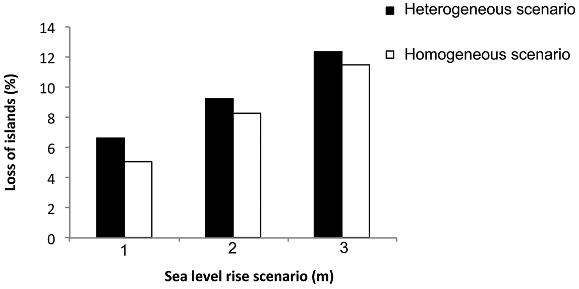
Percentage of islands entirely submerged under three scenarios (lower ≈1 m, middle ≈2 m and upper ≈3 meters) and two projections (homogeneous rise and heterogeneous rise).
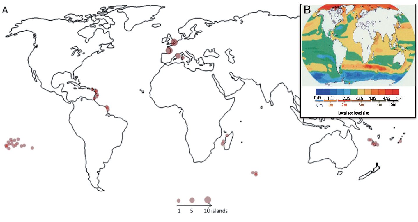
A Spatial distribution of submerged French islands following the pessimistic scenario (~3 m rise) B Local sea level change (m) due to ocean density and circulation change relative to the global average during the 21st century under SRES A1B scenario.
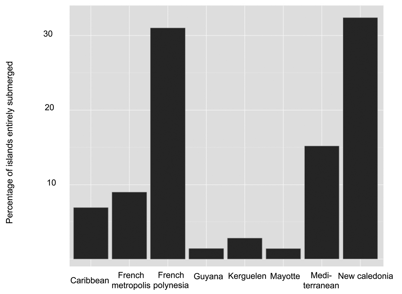
Spatial distribution of the entirely submerged islands for the different French regions under an increase of sea level by 3 meters.
Consequently, rising sea would potentially threaten a considerable part of French insular biodiversity, especially in New Caledonian region. Considering that at least 5% of the number of islands will be entirely submerged under an increase of sea level by 1 meter, many plants will be endangered by an increase of sea level as well as other species located in these islands. In addition, other islands that are not under French jurisdiction but that are located in these regions could be highly vulnerable to sea level rise, and the potential losses of insular habitat could be very similar at the world scale.
Because our results showed that New Caledonia region is particularly sensitive to sea level rise, we decided to study the potential partial losses in this region. Overall, our results showed that between 1.7 and 2% of New Caledonian area will be permanently submerged under an increase of sea level rise by 1 to 3 meters, respectively (Figure 4AB). Taking into account partial losses of New Caledonian islands, we estimated that between 2.3% and 6.8% of islands will have more than half of their area entirely submerged. With an increase of sea level by 1 meter, 29.5% of New-Caledonian islands will have between 1 and 25% of their area inundated. Based on our results, more than 50% of islands will be safe from permanent inundation because of their high elevation profile (Figure 4C) although we recognized that indirect effects of sea level rise such as lateral erosion could lead to significant effects for these islands.
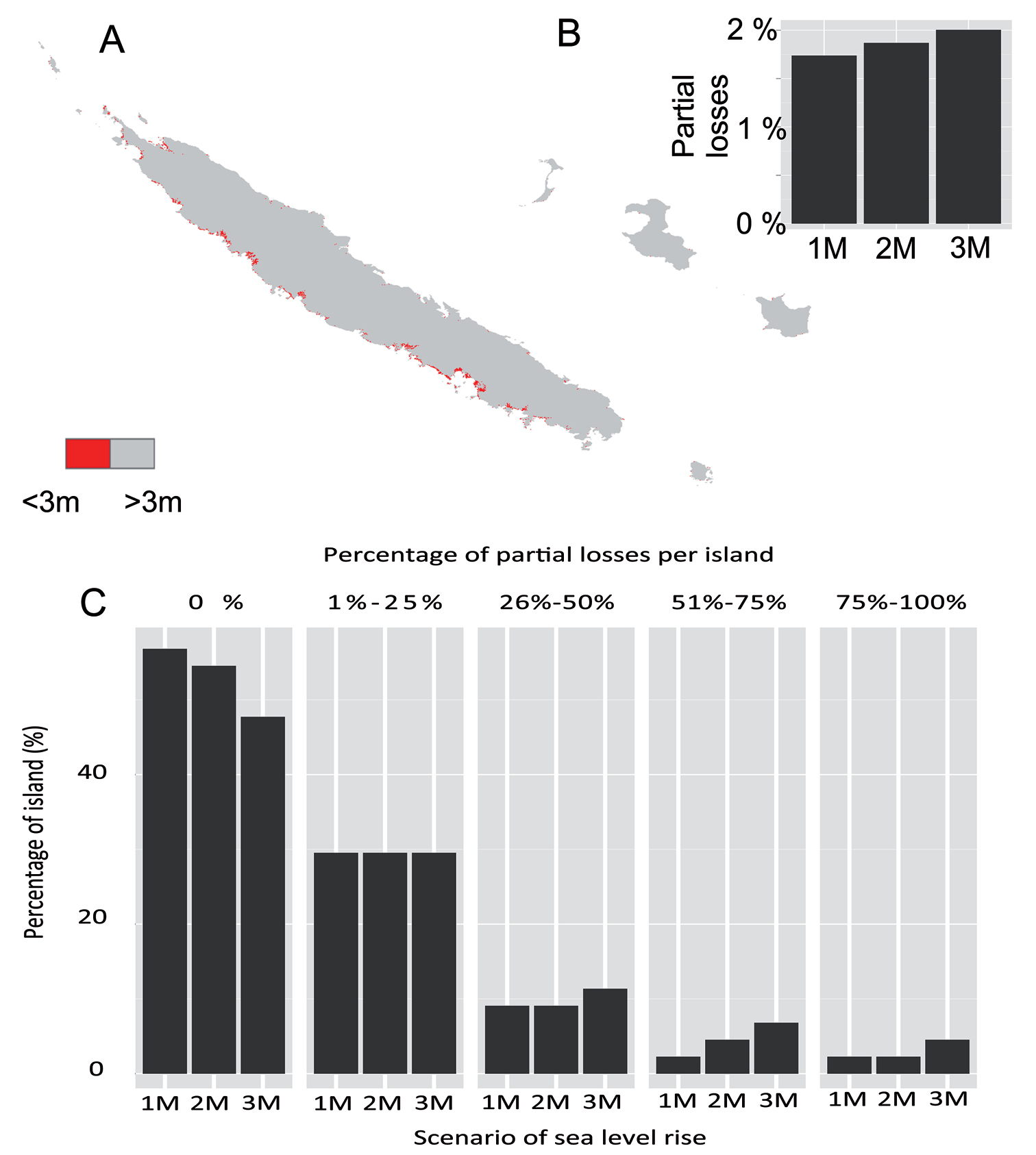
A Map representing the partial habitat losses of New Caledonia region with an increase of sea level by 3 meters B Percentage of areas partially submerged in New Caledonia region under an increase of sea level by 3 meters C Percentage of island that are partially submerged for different classes of submersion.
Using the endemic plant species distribution, we estimated the species area distribution that will be submerged under an increase of sea level by 1, 2 and 3 meters. We then calculated the potential area losses for each endemic plant species under the different scenario of sea level rise and we averaged according to the IUCN status. Overall, our results showed that endemic plant species will lose between 1.25% and 3.98% of their area distribution under an increase of sea level by 1 and 3 meters, respectively (Figure 5). With an increase of sea level of 3 meters, the habitat loss of the species that are classified as “least concern” by the IUCN was 1.16%, while it reached 6.88% for the “critically endangered” plant species. These results highlighted that the vast majority of endemic plant species vulnerable to an increase of sea level, are already at a high risk of extinction. Consequently, species that already are at higher risk of extinction will lose the largest habitat following sea level rise.
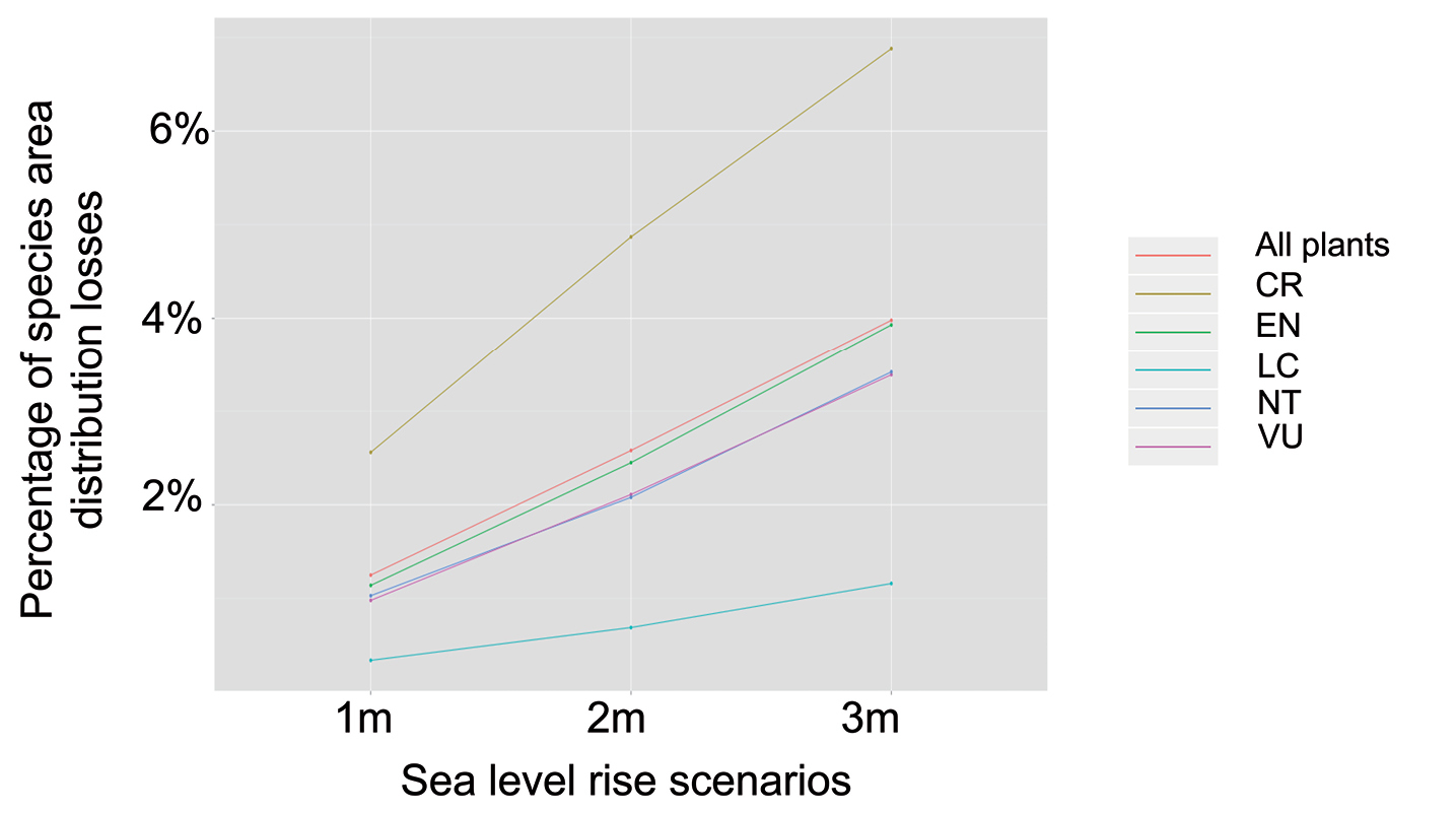
Percentage of species area distribution submerged under 3 different scenario of sea level rise for 64 endemic plants. We grouped the different species according to their IUCN status. CR: Critically endangered, EN: endangered, VU: vulnerable, NT: Near threatened and LC: least concern.
Over the next 60 years, sea level rise and higher storm frequency, together with natural and human-induced subsidence, population growth and urbanization, will cost roughly 9% of global GDP (
Then, regarding endemic species distributions over New Caledonia, we showed that species that are already at risk of extinction were the most vulnerable to sea level rise. This result is particularly important, because it means that endemic plants that are at risk of extinction are mainly located on the coastal areas. Although we focused on endemic plant species, rising seas will also flood other populations of different taxonomic groups including invertebrates and vertebrates. In addition, the two most important regions that are susceptible to be threatened by sea level rise are part of biodiversity hotspots. For instance, French Polynesia contains 85 of the 425 atolls of the world that shelter nearly 19, 000 vascular plant species including 3, 450 endemic species. These species may also have to face many threats such as salinity intrusion, submersion, soil erosion and climate changes.
We attempt a first approximation of the potential impact of sea level rise on French biodiversity following marine intrusion. In our study, most of islands that showed important vulnerability to sea level rise were atolls. Their remoteness from mainland, flat topography and great susceptibility to natural disturbances (e.g., hurricanes) might lead to a low biodiversity present in these islands. Thus, the biodiversity on small islands and other low-lying coastal regions appeared to be highly vulnerable to sea level rise, but it is unclear how many species could be lost under existing sea level rise projections. To conclude, some patterns emerging from this study provided useful information for conservation planning. As our climate continues to change at a faster rate than previous century, sea level rise will create further challenges for the conservation of insular ecosystem in French territories, and in low lying areas worldwide. Given that French islands covers all latitudes in the Pacific, Indian and Atlantic oceans and in the Mediterranean, with the French maritime domain being ranked as the second largest in the world, our results suggested that the implications for the 180 000 world islands around the world should be considerable. Assuming that French islands are representative of worldwide islands, roughly 10, 800 islands could be entirely lost with the 1 meter scenario. Consequently, new prioritizations programs for islands have to be established in order to mitigate the impacts of sea level rise. For example, in order to anticipate threats and prepare adequate conservation actions (e.g., local protection, identification of refuges or translocation programs), conservation managers have to target specific islands that have high risk of being permanently inundated within the next decades. Our results suggested that the effects of sea level rise will be particularly dangerous for New Caledonia, and French Polynesia. Considering their important contribution to global biodiversity and the threat of sea level rise for future biodiversity of some of these islands, there is an urgent need that islands feature prominently in global and regional conservation prioritization schemes. In addition, with accepted projections of sea level rise now exceeding one meter, the improvement of estimates of the associated loss of insular habitat and biodiversity becomes essential. In addition, it would be advantageous for decision makers to have more certainty about future sea level rise, the nonlinearity of ice-sheet melt makes accurately predicting the change in sea level at a particular date unattainable at present (
This work was funded by Centre National de la Recherche Scientifique (CNRS) and Agence Nationale de la Recherche (ANR). The authors are thankful to D. Harris and L. Bull who built the French island database and to H. Kreft for his valuable comments and interest on the manuscript in 2010. We also thank E. Bonnaud, S. Gregory, G. Luque, Y. Watary, P. Leadley, and A.P. Møller for their helpful comments on the manuscript. We are also greatly thankful to the referees of Peerage of science who provided constructive criticisms on en early version of this manuscript and to B. Brook for his valuable comments.